Help us shape the future of environmental risk monitoring. We're looking for motivated testers who can provide meaningful feedback. You'll receive a TestFlight invite to your email.
You're In!
Thanks for signing up! We'll send a TestFlight invite to your email soon. Keep an eye on your inbox (and spam folder, just in case).
Real-time weather and hazard insights drawn from trusted federal sources, organized into clear summaries for your exact location — so you always know what's happening and what to expect.
Swipe through real screenshots from NimboStratusAI and see what's waiting for you.
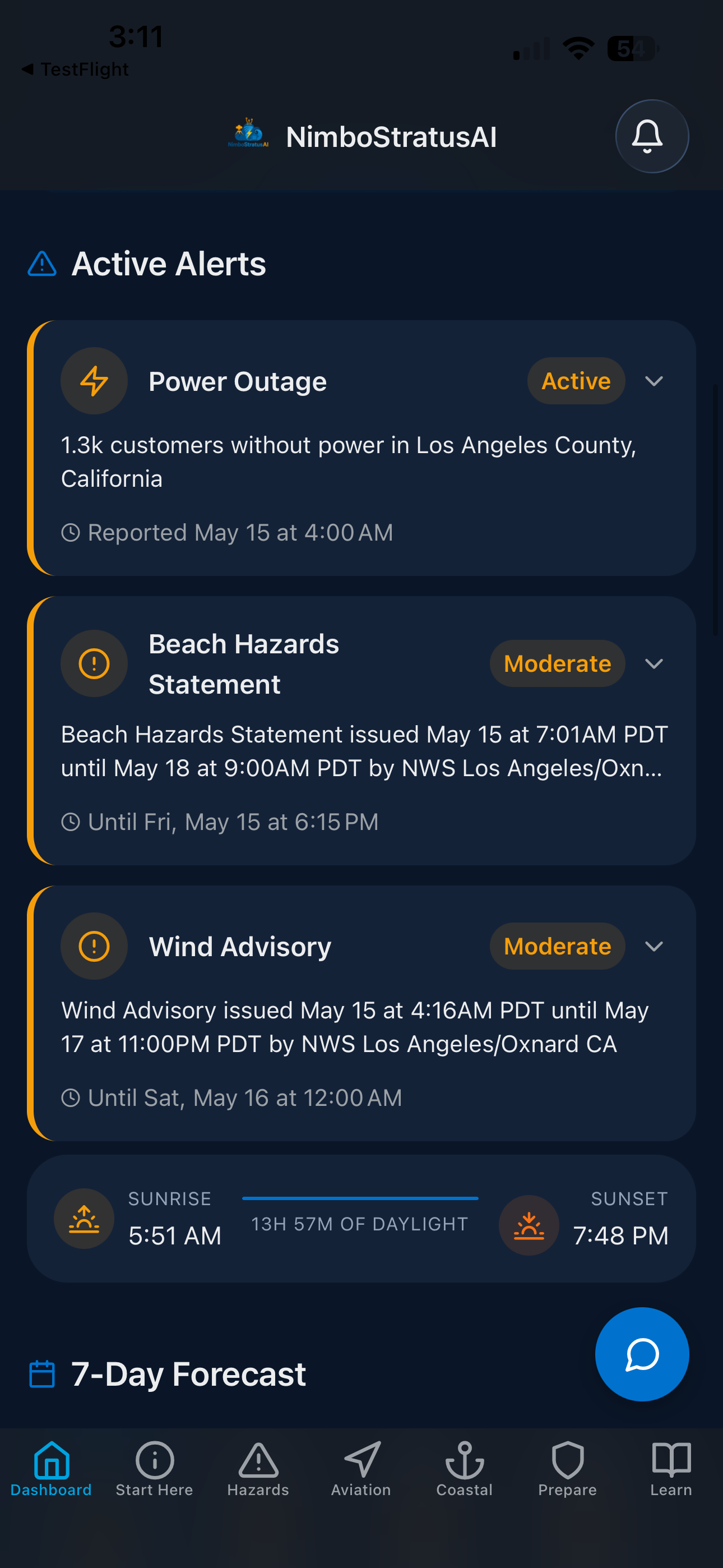
Live Active Alerts
Every active hazard for your location, the moment it's issued
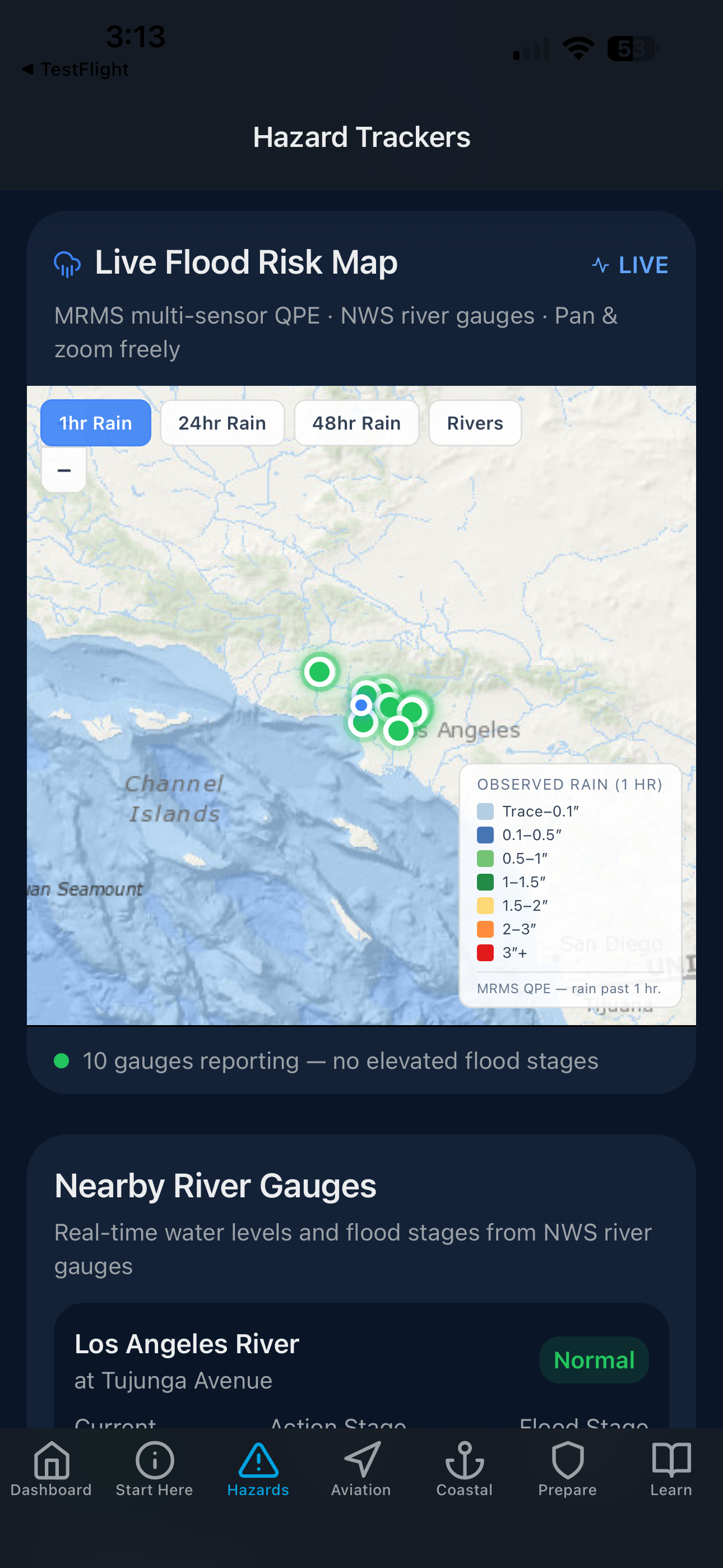
Live Flood Risk Map & River Gauges
See flood risk building in real time — before it peaks
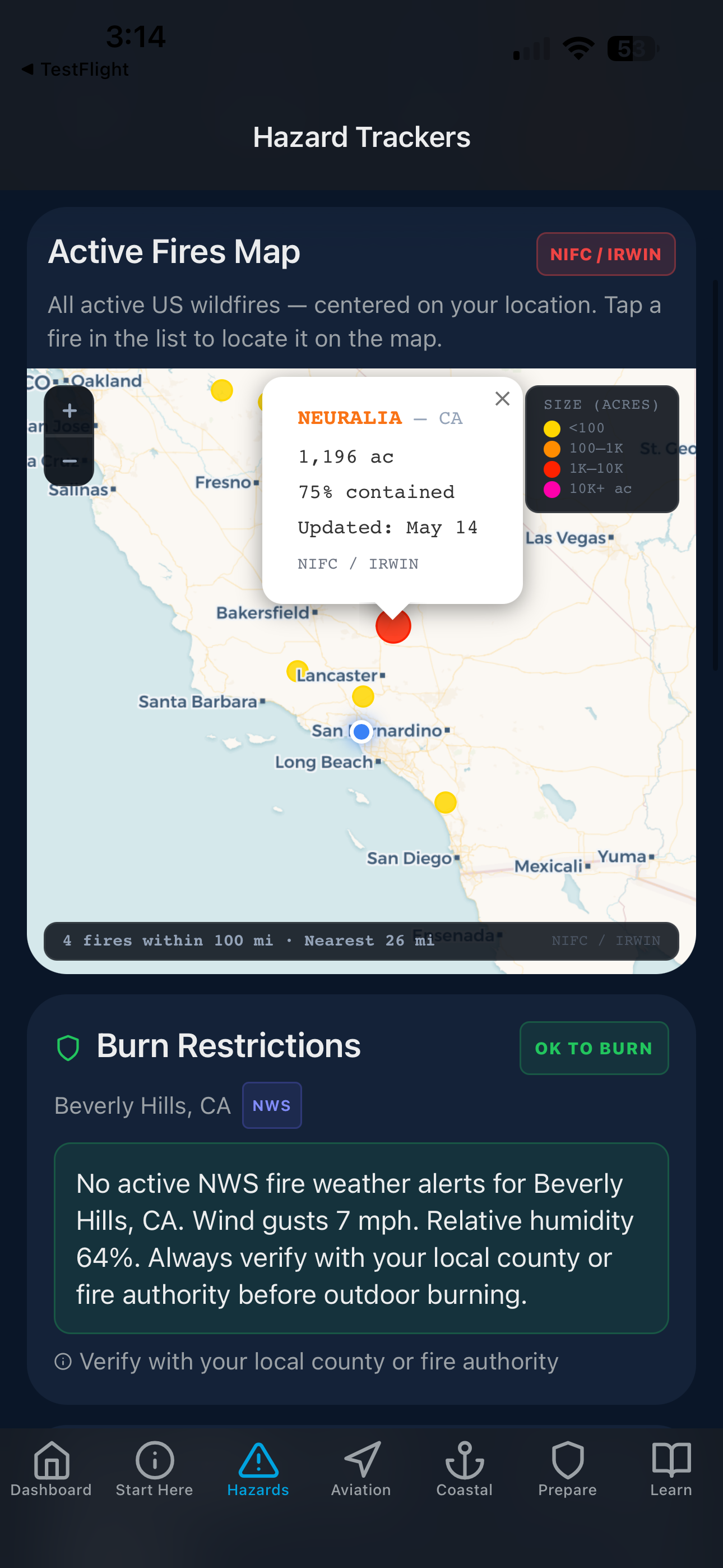
Active Fires & Burn Restrictions
Every active US wildfire — acreage, containment %, and county fire weather alerts
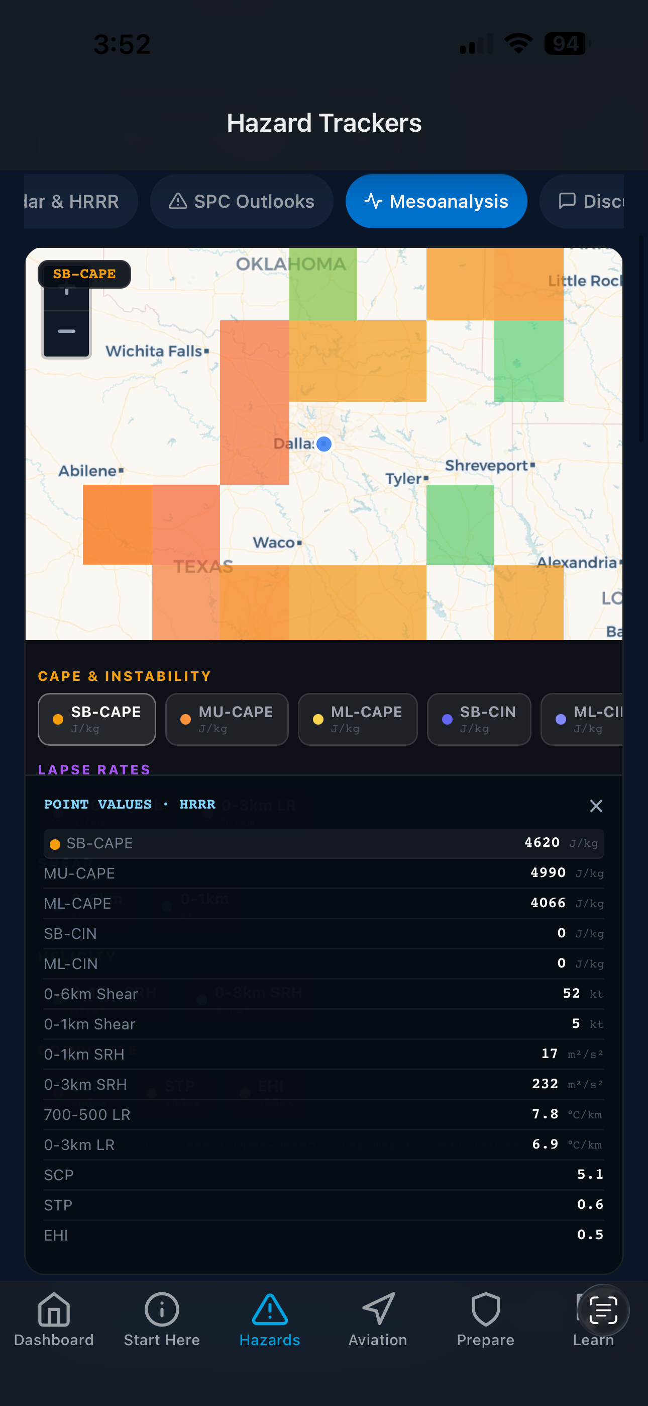
Mesoanalysis & Storm Environment
CAPE, STP, SCP, and wind shear — operational data for storm chasers and forecasters
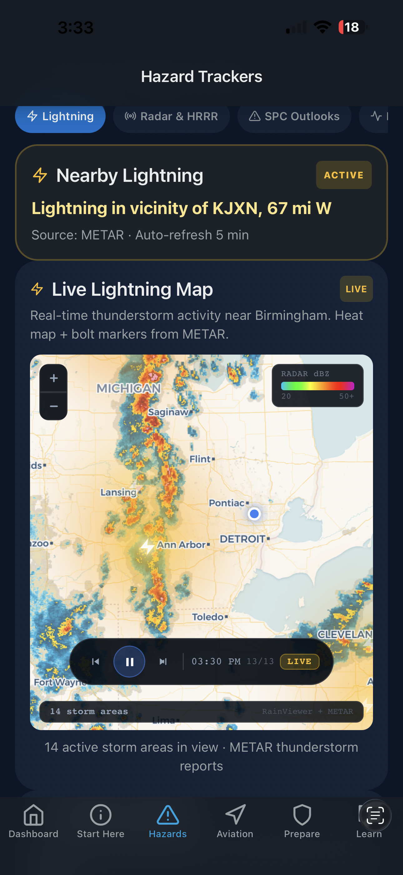
Live Lightning & Storm Tracker
Animated radar with METAR thunderstorm markers and proximity alerts
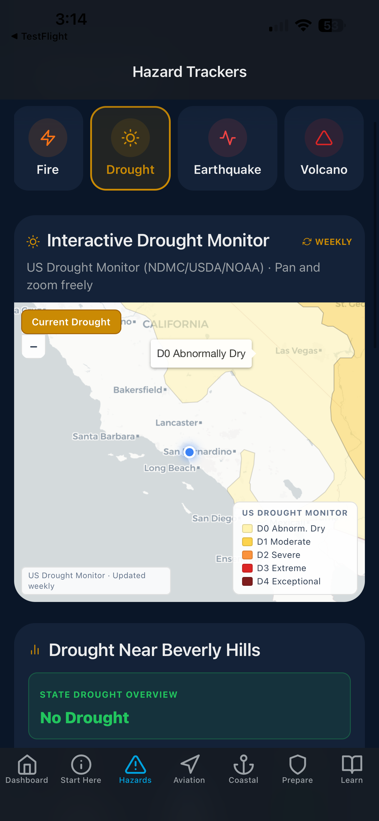
Interactive Drought Monitor
USDM drought severity D0–D4, pan and zoom to your county
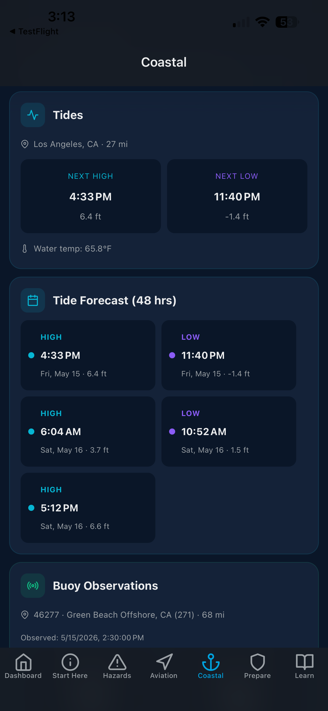
Tides, Buoys & Coastal Conditions
48-hour tide forecast, NDBC buoy data, and live marine alerts
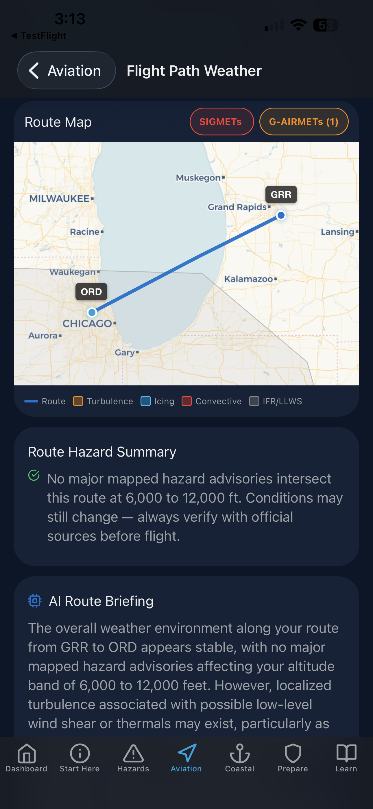
Flight Path Weather & Route Briefing
SIGMETs, G-AIRMETs, and turbulence plotted along your exact route
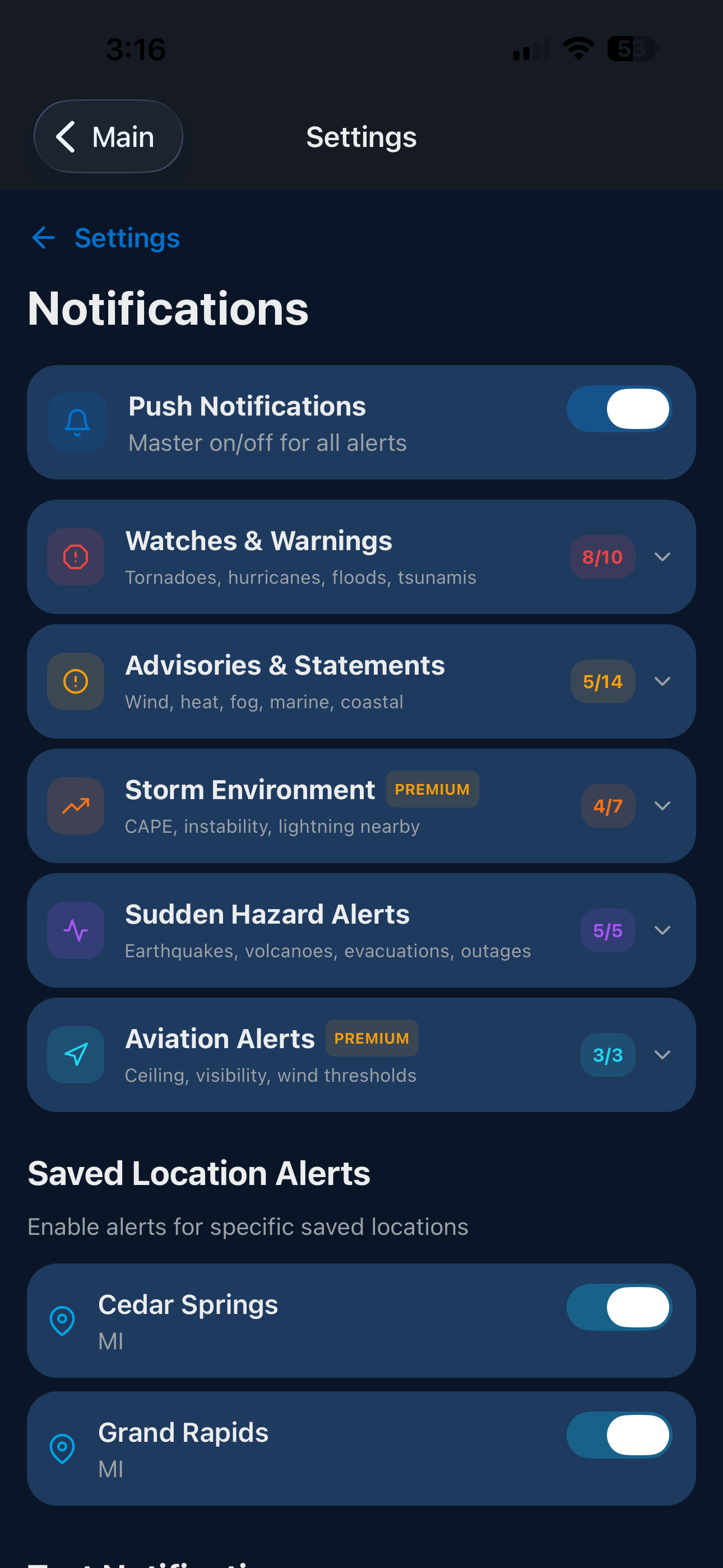
Alerts for Every Location You Monitor
Per-location alerts — tornadoes, evacuations, earthquakes, outages, and more
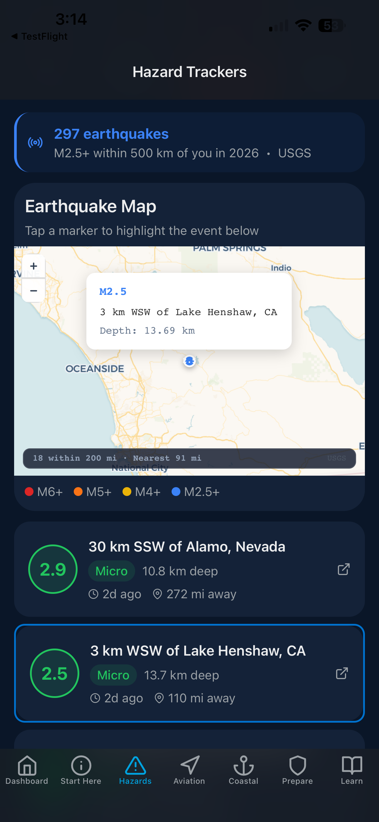
Real-Time Earthquake Tracker
297 USGS events mapped — magnitude, depth, and distance from you
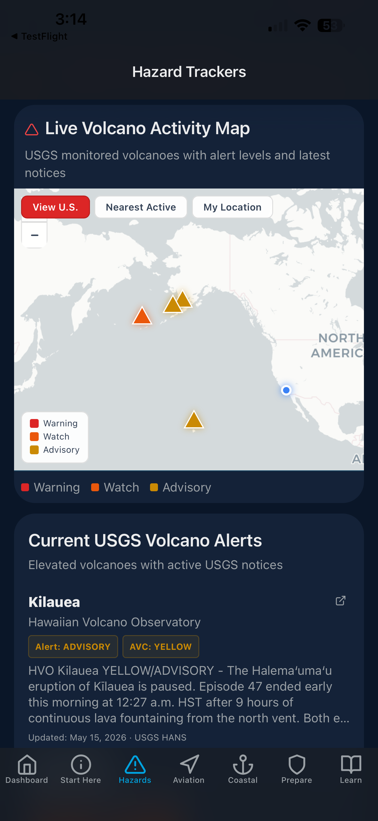
Live Volcano Activity & USGS Alerts
Warning, Watch, and Advisory levels mapped as notices are issued
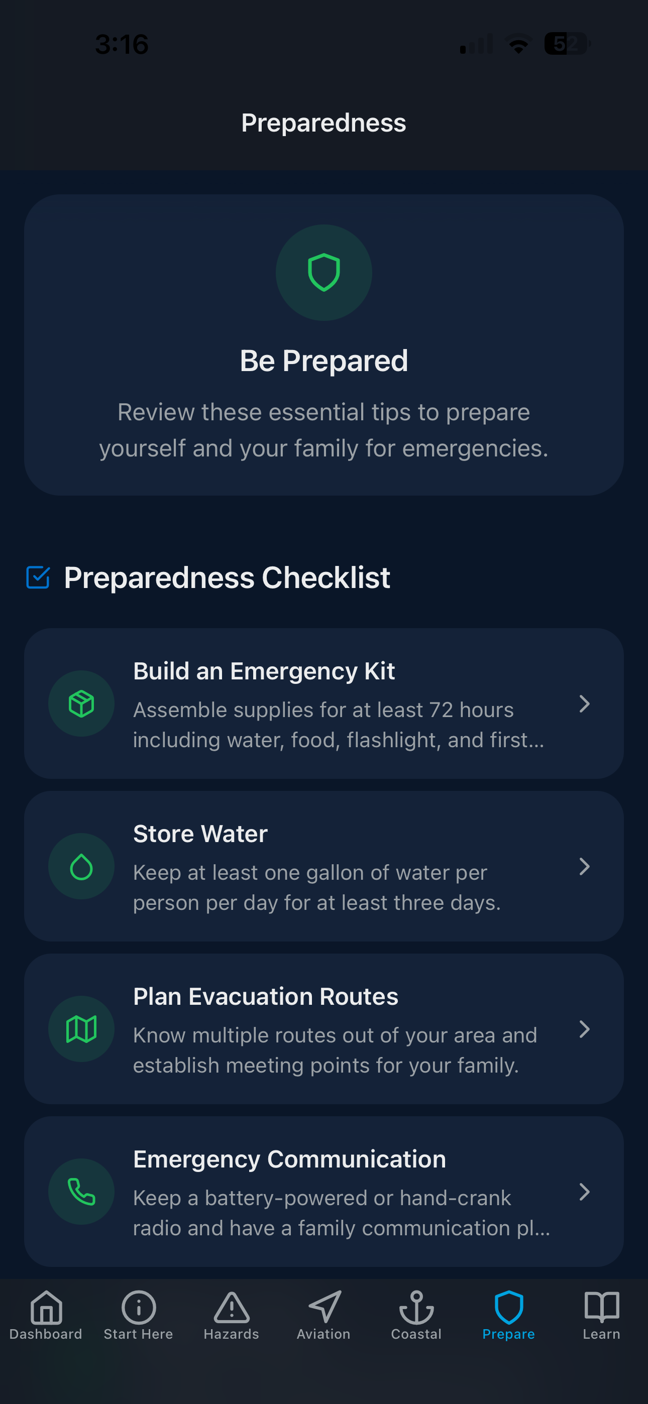
Emergency Preparedness Checklists
Go-bags, evacuation routes, water storage, and communication plans
Swipe to explore
Screenshots from the live NimboStratusAI app: real-time active alerts dashboard, live flood risk map with MRMS and river gauges, active wildfire and burn restriction monitoring, professional mesoanalysis and CAPE data, granular multi-location notification control, USGS earthquake and volcano tracking, and emergency preparedness checklists.
Features
Everything You Need to Stay Safe
NimboStratusAI brings together real-time data from federal agencies and scientific sources, organized into clear summaries for your exact location.
Live Weather & Emergency Alerts
Instant NWS alerts for your exact location: tornado warnings, severe thunderstorms, winter storms, flash floods, evacuation orders, and more. Every second counts.
Live Data
8 Hazard Trackers
Track storms, hurricanes, floods, wildfires, earthquakes, volcanoes, tsunamis, and drought. All in one place, updated continuously.
Live Data
Animated NEXRAD Radar
Live 20-frame radar loop from the nearest NEXRAD station. Switch between reflectivity, storm-relative velocity, and dual-pol hydrometeor class. Pinch to zoom to street level.
Premium
Real-Time Weather and Hazard Insights
Atmospheric data for your area is translated into plain-language summaries — covering current conditions, what's driving them, and what to expect in the days ahead.
Premium
Air Quality & UV Safety
Real-time AQI with PM2.5, PM10, ozone, and NO2 breakdown. UV index with SPF recommendations and sun safety guidance for your family.
Essential
Aviation Weather
METAR data from your nearest airport with wind, visibility, ceiling, temperature, and flight rules. Built for private pilots and aviation enthusiasts.
Live Data
Flight Path Weather
Enter your departure and arrival airports to see active SIGMETs, G-AIRMETs, turbulence, icing, and IFR conditions plotted along your exact route. Situational awareness for every leg of your flight.
Route Analysis
Ask NimboStratusAI
Ask questions about weather, natural hazards, climate change, or emergency preparedness. Answers are location-aware and drawn from real-time data in your area.
Ask Anything
Climate Education
Regional climate trends, FEMA disaster declarations, curated resources for all ages, and dedicated educational content for kids and families — all included with your subscription.
Included
Emergency Preparedness
10 detailed emergency checklists covering everything from go-bags to evacuation plans. Be ready before disaster strikes, not during.
Life-Saving
Power Outage Alerts
Real-time county-level power outage data from the U.S. Department of Energy — combined with NWS alerts — so you know the moment your area is affected.
Live Data
Now & Soon Insights
Short, plain-language summaries of what the weather is doing right now and what to expect in the next few hours — pulled from live NWS alerts and Open-Meteo atmospheric data.
Real-Time
Community Forum
Connect with earth scientists, meteorologists, climate researchers, aviation weather professionals, and weather enthusiasts from around the world.
Join Now
Interactive Earthquake Map
Live seismic activity mapped in real time from USGS Earthquake Hazards data. Filter by magnitude, depth, and time range to see recent quakes near your location. Plain-language analysis explains what each event means, including aftershock potential and regional fault context.
Premium
Interactive Drought Map
Live US Drought Monitor conditions layered on an interactive map. See current drought severity — from abnormally dry to exceptional drought — updated weekly from NOAA and USDA data. Track drought expansion, contraction, and long-term precipitation deficits across the country.
Premium
Live Volcano Tracker
Interactive map of active US volcanoes and recent eruption events sourced from the USGS Volcano Hazards Program. Filter by alert level — Normal, Advisory, Watch, and Warning — and view eruption history, lava flow activity, and ash cloud hazards. Detailed analysis breaks down what each event means for your area.
Premium
Coastal & Tsunami Hazards
Real-time tsunami event tracking from NOAA's historical database, with earthquake-triggered wave alerts and coastal threat assessments. Includes storm surge outlooks, coastal flood warnings sourced from NWS, and evacuation zone awareness for residents in low-lying coastal areas.
Live Data
Aurora Tracker
Real-time geomagnetic storm monitoring with live Kp index, NOAA Space Weather Center alerts, and aurora visibility forecasts for your latitude. Know exactly when and where the northern lights are visible — from mild G1 events to rare G5 extreme storms.
Premium
NimboStratusAI pulls live data from NOAA, the National Weather Service, USGS Earthquake Hazards, the National Hurricane Center, the Storm Prediction Center, FEMA IPAWS, and the US Drought Monitor. Whether you need real-time weather alerts, storm chaser tools, river gauge flood monitoring, aviation weather briefings, wildfire smoke and AQI tracking, drought monitoring, or hurricane tracking, NimboStratusAI delivers authoritative environmental intelligence in one place — for free on iOS and Android.
Transparency
How NimboStratusAI Uses AI
NimboStratusAI uses AI to help turn complex weather, hazard, and environmental data into clearer summaries and easier-to-follow situational awareness. The AI does not replace official forecasts or alerts. Instead, it helps organize and explain information from trusted sources so users can better understand changing conditions in real time.
Simplifies complex weather and hazard information
Raw atmospheric data, NWS bulletins, and scientific readings are condensed into plain language that is easier to act on.
Helps explain active conditions in plain language
When a warning or watch is issued, the AI can describe what it means for your specific area without relying on technical jargon.
Supports real-time situational awareness using trusted data sources
All AI analysis is grounded in live data from NOAA, the National Weather Service, USGS, and other federal agencies — not generated from general knowledge alone.
AI analysis is a Premium feature. Official NWS alerts, watches, and warnings are always displayed exactly as issued and are never altered or interpreted before reaching you.
What You Get
Free vs. Premium
The core app is free with no account required. Upgrade to unlock every tool — animated radar, storm chasing, in-depth analysis, and more.
Always Free
Live NWS weather alerts & evacuation orders for your ZIP
Power outage alerts — county-level, DOE real-time data
Push notifications — severe alerts, CAPE/supercell potential, evacuation orders
SPC watch details — county lists & expiry times
Up to 5 saved locations
Dashboard quick links — SPC, NHC, Drought Monitor
Full Learn & education library
AI climate trends & regional analysis
How It Works
Safety in 4 Simple Steps
1
Enter Your ZIP Code
We pinpoint your exact location to pull hyper-local data from federal sources.
2
View Live Hazards
See active alerts, forecasts, air quality, UV index, and satellite imagery instantly.
3
Ask About Your Area
Ask NimboStratusAI about weather patterns, climate risks, or disaster preparedness for your location.
4
Stay Prepared
Access checklists, educational resources, and climate trends to keep your family safe.
Trusted Data
Powered by Authoritative Sources
We aggregate real-time data from the most trusted federal agencies and scientific organizations.
National Weather Service
NOAA / GOES-16 Satellite
USGS Earthquake Hazards
Storm Prediction Center
National Hurricane Center
US Drought Monitor
FEMA / IPAWS Emergency Alerts
DOE / ODIN Power Outage Data
FAA Aviation Weather
Open-Meteo Air Quality
OpenAI GPT
All weather alerts originate from the National Weather Service (NWS). Earthquake data is sourced from the USGS Earthquake Hazards Program. Hurricane and tropical storm data is provided by the NOAA National Hurricane Center. Drought conditions come from the US Drought Monitor, a collaboration between NOAA, USDA, and the University of Nebraska-Lincoln. Aviation weather data is sourced from AviationWeather.gov. Wildfire smoke and air quality data are derived from EPA AirNow, Open-Meteo, and NASA EONET. NimboStratusAI does not generate original forecasts — we aggregate and interpret operational weather data from trusted federal sources.
Our Team
Built by Scientists, for Everyone
Founded by environmental scientists from Mississippi State University with a mission to democratize environmental risk awareness.
Alicia Skiver-Palmer
Chief Executive Officer & Environmental Scientist
With a Master’s degree in Geoscience from Mississippi State University and a certificate in Weather Forecasting from Penn State, Alicia combines scientific expertise with leadership to guide NimboStratusAI’s mission. Her background in environmental science and passion for severe weather—especially storm chasing—drive the platform’s focus on accessible, real-time hazard alerts that empower everyday users.
Alana Shuvalau
Co-Founder & Hydrometeorologist
Alana holds a Master’s degree in Applied Meteorology from Mississippi State University and has contributed to NOAA’s groundbreaking work on Atlas 15. With a strong background in both meteorology and hydrology, she brings deep scientific insight to NimboStratusAI. Her earlier studies in Geography and Geospatial Sciences help bridge complex data with real-world hazard forecasting.
Tristan Skiver-Palmer
Junior Data Analyst (Youth Advisor)
Tristan contributes to feature testing, real-world accuracy checks, simplifying how weather data is presented, and developing new ideas to improve the platform. With a strong natural ability to quickly understand complex scientific and technical concepts, he has developed scripting skills and a deep interest in technology and science at an early age. He brings a fresh perspective that helps ensure the app is intuitive and useful for everyday users.
Support
We're Here to Help
Have a question, feedback, or need assistance? Reach out anytime.
Email Us
General inquiries, feature requests, or feedback — we'd love to hear from you.
The core app is free forever. Subscribe to unlock premium tools — animated NEXRAD radar, full Storm Chaser suite, AI analysis, and much more. Every plan includes the same features; the only difference is how long you subscribe.
1 Week Free Trial — No Charge Until Your Trial Ends
Subscriptions auto-renew at the end of each billing period unless canceled at least 24 hours before the renewal date. Your free trial begins when you subscribe and ends after 7 days — you will not be charged until the trial period ends. Manage or cancel anytime in your Apple ID Settings. Prices shown in USD.
Get the App
Your Safety Starts Here
Download NimboStratusAI and start monitoring environmental risks in your area today. Don't wait for the next disaster to wish you had it.